This gorgeous hike travels up a seldom visited valley to a scenic lake tucked in a high basin. Here you will experience a level of solitude not found on hikes to the nearby 14ers. Extend the hike by climbing to a saddle overlooking Lee Smelter Gulch to the north.
- Distance: 7.6 miles (RT)
- Elevation: 10,650-ft. at Trailhead
Maximum elevation - 12,750-ft. - Elevation Gain: 2,100-ft.
- Difficulty: moderate-strenuous
- Basecamp: Lake City
- Region: Southwest Colorado
Trail Description - Cooper Lake
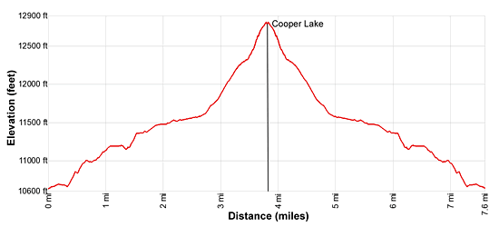
The trailhead for Cooper Lake is located along CR 30, part of the Alpine Loop Road. (See driving directions below.) On the north side of the road follow the old jeep road (2-track) as it curves around and enters the Cooper Creek Valley, reaching a trail registration box at 0.4 miles. The trail now heads northeast, climbing on moderately-steep grades through forest and intermittent meadows. After walking 1.1 miles the grade levels and then drops gently down to cross the creek at 1.4 miles. Early in the season you will need to wade the creek. Otherwise it is not a problem.
Climb a switchback up the valley’s eastern slopes and then enter the trees, passing the ruins of a cabin at 1.7 miles. The trail now ascends up the classic “V-shaped” valley on easy grades, traveling through pretty meadows and scattered trees beneath 13,000-ft. peaks. CT Peak (13,312-ft.) and Gudy Peak (13,566-ft.) rise to the west while Peak 13,484-dominates the view at the head of the valley.
Cross back to the west side of the creek at 2.6 miles. A short distance beyond the creek crossing the trail starts a steep climb up the lowers slopes of Gudy’s eastern ridge. You are now ascending toward the lower basin of the West Fork of the Cooper Creek Valley.
As you climb enjoy fine views of Peak 13,484-ft and Every Mountain (13,691-ft.) soaring above the head of the valley. Soon views open up the length of the East Fork of the Cooper Creek Valley. Cooper Peak (13,689-ft.) anchors the cirque of 13,000-ft. peaks ringing the head of the East Fork.
At 3.2 miles the path curves to the left (north/northwest) as the steep ascent to the lower basin continues along the west side of Cooper Lake’s outlet stream. The grade abates a bit as the trail reaches the lower basin at 3.4 miles. Here the trail fades as it crosses the lower basin. Watch for cairns marking the route, which stays to the south of a boggy area. Ahead, scree spills down the upper basin’s steep headwall.
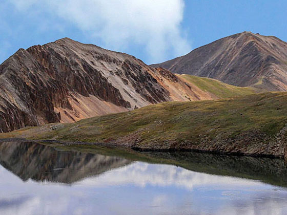
Soon the steep ascent resumes through tundra and talus-clad slopes up the left (south) side of the headwall. Cross the outlet stream at 3.7 miles and climb on moderate grades to the upper basin and Cooper Lake (12,750-ft.) at 3.8 miles. The stunning lake lies at the foot of a rugged cirque of 13,000-ft. peaks. Gudy Peak towers above the lake to the west. Steep scree-covered slopes ring the north side of the lake.
From the upper basin views extend east to the high peaks rimming the head of the Cooper Creek Valley.
Elevation Profile

Driving Directions
Driving Directions from Lake City: From the intersection of Highway 149/Gunnison Ave and 4th Street, head south on Highway 149 for 2.5 miles and turn right on CR 30, the Alpine Loop Road, toward Lake San Cristobal. Reset your odometer here. Follow CR 30 for 12.1 miles to a “Y” intersection. Bear right here to stay on CR 30. The road now becomes rougher and soon travels along a shelf below Sunshine Peak for 1.5 miles. Pass the Silver Creek/Grizzly Gulch trailhead at 16.2 miles. The unmarked trailhead for Cooper Lake is located at 17.0 miles. On the left (south) side of the road you will see a small parking area. On the north side of the road is an old 2-track jeep trail. This is the beginning of the trail.
A high clearance vehicle is recommended for reaching the trailhead. 4WD is required if the road is wet. Check road conditions at the Lake City Visitor Center before starting out on this hike.
Trail Resources
- Trail Photo Gallery
- Trail Maps
- Basecamp(s) Information: Lake City
- Region Information: Southwest Colorado
- Other Hiking Regions in: Colorado
