Ammerten Pass and the Ammertenspitz 
Distance: 5.5 - 6.5 miles (round trip)
Bernese Oberland, near Kandersteg in Bernese Oberland
Ascend the beautiful Engstligenalp valley to scenic Ammerten Pass with great views of the peaks surrounding the valley and the mountains rising to the south. From the pass a steep trail leads to the Ammertenspitz summit with panoramic views encompassing the summits towering above Adelboden, Lenk and beyond.
See Trail Detail/Full Description
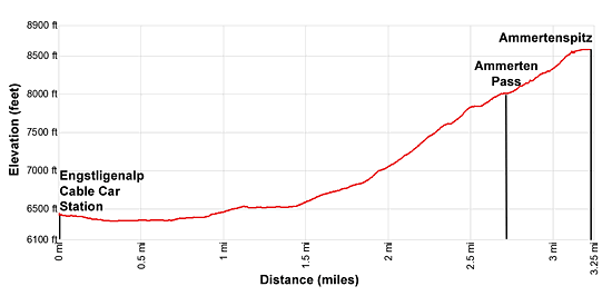
- Distance: 5.5 miles (round trip) to Ammerten Pass
6.5 miles (round trip) to Ammertenspitz - Elevation: 6,437-ft. at Trailhead
8,015-ft. at Ammerten Pass
8,573-ft. at Ammertenspitz - Elevation Gain: 1,578-ft. to Ammerten Pass
2,138-ft. to Ammertenspitz - Difficulty: moderate-strenuous
- More Hikes in:
Kandersteg / Bernese Oberland
Why Hike Ammerten Pass and the Ammertenspitz
A trip to Ammerten Pass and the summit of the Ammertenspitz offers a terrific perspective of the high peaks rising above Adelboden and the neighboring valleys. The day starts with an easy walk up the Engstligenalp Valley, a large meadow-clad bowl ringed by rugged peaks and ridges, followed by a moderate to steep climb up the east facing slopes of the Ammertenspitz to the pass. The pass, a broad saddle between the Ammertenspitz and Wildstrubel massif, boasts great views of the Engstligenalp cirque, the summits rising to the south/southwest of the pass as well as the high peaks soaring above Adelboden and Kandersteg.
Hikers with the time and energy will want to continue the hike to the summit of the Ammertenspitz, which adds 1.0 mile (round trip) and 558-ft. of elevation gain to the hike. The summit enjoys birds-eye-views of the summits seen from the pass in addition to vistas extending to the peaks rising around Lenk and the valleys to the west.
Elevation Profile

Support our Site | |
Trail Resources
Trail Detail/Full Description / Trail Photo Gallery / Trail Map
Basecamp(s) Information:
Kandersteg
Region Information:
Bernese Oberland
Other Hiking Regions in:
Switzerland

