Get off the beaten path with this scenic hike climbing to Fuorcla Pischa, a high pass at the head of Val Languard. The hike enjoys great views of the glacier clad Bernina massif, Piz Languard and the stark basin, sprinkled with tarns, below Pischa Pass.
See Trail Detail/Full Description
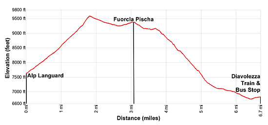
- Distance: 6.7 miles (one way) to Fuorcla Pischa and Bernina Suot
- Elevation: 7,631-ft. at Trailhead
9,600-ft. at Fuorcla Pischa and Bernina Suot - Elevation Gain: 1,965-ft. to Fuorcla Pischa and Bernina Suot
- Difficulty: moderate-strenuous
- More Hikes in:
St Moritz / Eastern Switzerland
Why Hike Alp Languard to Fuorcla Pischa
This varied and beautiful hike climbs along the southwest facing slopes between Piz Muragl and Piz Languard to the junction with the trail to Piz Languard. Beyond the junction the path traverses below the Crasta Languard (Languard ridge) to Fuorcla Pischa (9,341-ft.), an alpine pass overlooking a rocky basin dotted with tarns. Piz Albris, Piz Pischa and Piz dal Fain rise above the basin. From the pass the trail descends steeply to the Val da Fain and then travels down the valley to Alp Bernina and Bernina Suot.
The hike offers a degree of solitude not found on many of the trails in the St. Moritz area. After passing the junction with the trail to Piz Languard you will have the path mostly to yourself. The remainder of the hike travels through an untamed moonscape of rock and small tarns and then a wild valley where ibex seem to outnumber hikers. Only after dropping into the Val da Fain will you start seeing hikers and bikers.
Pick a nice day for this hike. Long sections of the trail are above timberline on exposed slopes, not the place to be during a thunderstorm. Snowfields linger into mid-July around the pass making the crossing problematic early in the season.
Elevation Profile

Support our Site | |
Trail Resources
Trail Detail/Full Description / Trail Photo Gallery / Trail Map
Basecamp(s) Information:
St Moritz
Region Information:
Eastern Switzerland
Other Hiking Regions in:
Switzerland

