Hike Facts
- Distance: 10.2 - 14.2 miles (loop)
- Elevation: 7,060-ft. - 9,820-ft.
- Elevation Gain: 2,050-ft. - 2,760-ft.
- Difficulty: strenuous
- Trail Highlights: See Trail Intro
- Basecamp(s): Driggs / Jackson Hole
- Region: Tetons

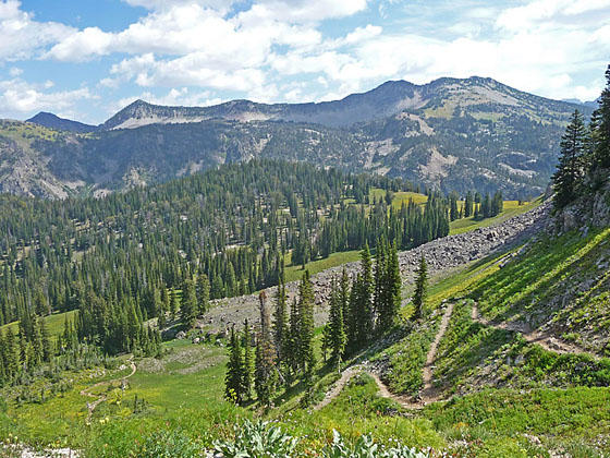
Ascend through forest and meadows to the Green Lakes Basin at the head of North Leigh Canyon, tucked between Green Mountain and the Continental Divide. Extend the hike by crossing the divide to Granite Basin Lakes, nestled at the head of South Leigh Canyon.
Trailhead to Green Lakes
Distance from Trailhead: 10.2 miles (round trip)
Ending/Highest Elevation: 9,110-ft.
Elevation Gain: 2,350-ft.
From the northwest end of the parking area (see driving directions below), the trail crosses Tin Cup Creek, passes the Jedediah Smith Wilderness sign and then curves to the right (east) as it ascends on moderate grades through forests and intermittent meadows. Along the way the trail swing southeast as it continues to climb at a steady pace.
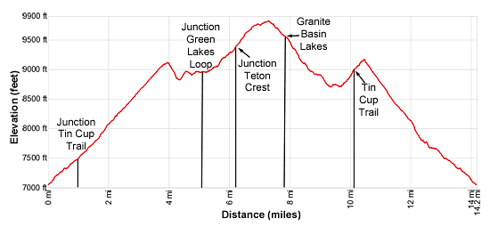
After a mile reach a “Y” intersection. Here the Tin Cup Trail, the return leg of the longer loop, branches right. We bear left (northeast) on the Green Mountain Trail, which switchbacks up the west facing slopes of Green Mountain. Soon the trees give way to beautiful meadows awash in wildflowers during the height of the summer. As you ascend views open south to Beard Mountain (9,466-ft.) and north to the ridge rimming North Leigh Canyon.
At the top of the switchbacks (3.2 miles) the trail swings south east and continues climbing toward the top of the ridge. Ahead views soon open to the summit of Green Mountain (9,614-ft.).
Crest the ridge at 3.8 miles. The summits of Cleaver Peak (11,065-ft.) and Maidenform Peak (11,137-ft.), in Grand Teton National Park, rise above Continental Divide to the southeast.
The path now ascends along the west side of the ridge. Reach a saddle on the ridge at 4.0 miles. To the east are fine views of the 10,000-ft. peaks and ridges forming the Continental Divide. Ahead a use trail climbs toward the summit of Green Mountain.
Our trail now turns left (east) and descends steep switchbacks for 0.3 miles to a bench along the east facing slopes of Green Mountain. Along the way enjoy nice views down North Leigh canyon.
Turn right (south) at 4.3 miles on an undulating path along the bench, passing a small tarn at 4.7 miles. The rugged slopes of Green Mountain tower above the trail to the west. Ahead Littles Peak (10,712-ft.) rises above the ridge at the head of the Green Lakes Basin.
At 5.1 miles reach a junction with the trail heading toward the Upper Green Lakes branching left. To the right is the continuation of the Green Mountain trail toward the head of the valley and Granite Basin.
You now have a choice. The easiest option is to follow the Upper Green Lake trail a short distance and then turn left, finding a nice place to sit on the smooth granite outcroppings that overlook the basin. Below you are nice views of the largest of the Green Lakes. Green Lake Mountain rises along the Continental Divide to the north. Across the valley are fine views to the peaks rimming the Continental Divide above the Green Lakes Basin. Alternatively drop 100-ft. down the north shore of Green Lake to fish and enjoy the lake shore.
When you are done enjoying the views and/or the lake, retrace your steps to the trailhead for a 10.2 to 10.6 miles round-trip hike. Total elevation gain on the hike is 2,350-ft.
The second option is to loop around the Green Lakes Basin before returning via the Green Mountain Trail. Alternatively, stay on the Green Mountain trail and cross the divide, visit the Granite Lakes Basin and then returning via the Tim Cup trail. Both options are covered below.
Green Lakes Basin Loop
Distance from Trailhead: 13.6 miles (loop)
Ending/Highest Elevation: 9,395-ft.
Elevation Gain: 2,335-ft.
The loop around the Green Lakes Basin visits four lakes and passes a few small tarns, adding 3 miles to the Green Lakes hike. At the junction at 5.1 miles, bear left on the Upper Green Lake trail, which loses 100-ft. in 0.2 miles as it drops down to the north shore of the largest lake in the basin. Here the trail turns east, crosses the lake’s outlet stream and then travels along the north shore.
Beyond the lake the trail ascends through small meadows and granite outcroppings scattered with trees, gaining 250-ft. as it climbs to the west short of the second lake at 0.75 miles. The path now turns left (north), travels along the lake’s western shore and then ascends the rocky slopes at the head of the lake. After gaining over 100-ft. the grade eases. The trail now passes a small tarn and then crosses the outlet stream for the third lake, surrounded by marshy meadows to the east.
At 1.2 miles the trail turns right (east), traveling above the north shore of the third lake. At 1.4 miles the trail arrives at the junction with the Teton Crest Trail. Continue straight ahead on the Teton Crest Trail, which curves to the right (south) and soon climbs to the upper basin. Here we traverse the eastern shore of the fourth lake, crossing the lake’s outlet stream along the way.
Beyond the head of the last lake the trail ascends gently, passing a few tarns before arriving at a junction at 2.25 miles. At the junction the Teton Crest trail turns left and climbs to the divide separating the Green Lakes Basin from the Granite Lakes Basin. We turn right on the Green Mountain trail, which loses 500-ft. as it descends back to the junction above the largest of the Green Lakes and the end of the loop at 3.4 miles. At the junction we follow the Green Mountain trail back to the trailhead for a 13.6 mile hike.
To Granite Basin Lakes and Completing the Loop
Distance from Trailhead: 14.2 miles (loop)
Ending/Highest Elevation: 9,820-ft.
Elevation Gain: 2,760-ft.
If you have the time and energy I recommend the longer loop, crossing over the divide into the Granite Lakes Basin and then returning via the Tin Cup trail. Note this is a strenuous hike requiring a 490-ft. climb to exit Granite Lake Basin and return via the Tin Cup Trail.
At the junction at 5.1 miles, bear right on the continuation of the Green Mountain trail toward the head of the valley and Granite Basin. The trail now curves to the southeast as it ascends on moderate grades around the west side of the Green Lake Basin, reaching the junction with the Teton Crest trail at 6.2 miles. Here the Green Mountain trail ends. To the left the north-bound Teton Crest trail travels northeast around the head of the Green Lakes Basin. We continue straight ahead on the south-bound Teton Crest trail toward Granite Basin.
At 6.8 miles the grade abates as the trail reaches the broad ridge separating the Green and Granite Lakes Basins. Ahead are fine views of Little Peak. The trail now travels through alpine meadows across the broad ridge.
At 7.2 miles the trail descends on moderate grades into the Granite Lakes Basin, dropping through meadows set amid granite outcroppings and scattered trees with nice views of the basin. Littles Peak towers above the basin to the south.
At 7.5 miles the trail turns right (west) and soon passes the south shore of a pretty lake nestled in pretty meadows. A larger lake is seen in the basin below the trail to the south.
Beyond the lake the path drops steeply, curving to the right (north) at 8.0 miles and then left (west) at 8.4 miles. The grade briefly abates as the trail travels through a marshy basin. At the end of the basin a short, steep ascent leads to the junction with the South Leigh Creek trail branching left. We continue straight ahead on easy grades along the Andy Stone Trail.
At 9.5 miles the trail starts the moderate to moderately-steep climb out of Granite Basin, climbing 470-ft. over 0.8 miles. As the trail climbs views open to Mount Owen, Grand Teton, Middle Teton, South Teton and Battleship Mountain rising beyond the Continental Divide. The best views are at 9.8 miles where the trail curves to the right as it crosses a ridge.
Beyond the ridge the path ascends northeast, reaching a junction at 10.1 miles. Here the Andy Stone trail turns left (west). We continue straight ahead on the Tin Cup Trail that climbs to a saddle (9,170-ft.) on the ridge extending east from Beards Mountain at 10.3 miles.
From the saddle the trail descends on moderately steep grades through meadows with scattered trees. The west facing slopes of Green Mountain rise above the trail to the west. At 11.4 miles the trees give way to beautiful meadows.
The grade steepens briefly at 11.9 miles. At 12.2 miles the grade abates as the path crosses Tin Cup Creek and then continues descending on moderate grades through meadows and scattered trees to the junction with the Green Mountain Trail at 13.2 miles. We now retrace out steps back to the trailhead for a 14.2 miles hike.
Elevation Profile

Driving Directions
From Driggs, ID: From the traffic light on Main St./ID-33 W drive north on ID-33 for 5.6 miles. As the road turns to the left (west) continue straight ahead, exiting the highway on to N 500 West. Take the first right (0.2 miles) on to W 5750 North Road. Follow the road for 0.5 miles and take the first left onto N Baseline Road. The road soon curves to the right and becomes E 6000 N. Follow E 6000 N for 1.9 miles and turn left on the North Leigh Creek Road. A sign for North Leigh Creek marks the turn. Follow N Leigh Creek for 6.6 miles to the trailhead parking area at the end of the road. The road is initially paved but soon turns to gravel/dirt.
Note: Toward the end of the road you will first reach a parking area with a dirt turn-around. This area is for horse trailer parking. Continue along the road heading southeast along a dirt track that ends in a smaller parking area on the left. The trailhead is on the northwest side of the parking area.
From Jackson, WY: Head south/southwest through Jackson on US 191 S / US 26 W. At the southwest end of town turn right on WY-22 W. (A large Albertson’s Supermarket is located on the southeast corner of the intersection. Follow WY-22 W for 36.9 miles. The route will cross Teton Pass and entering Idaho, where the road becomes ID-33 and pass through Victor and Driggs, ID.
As the road turns sharply to the left (west), 5.6 miles from the only traffic light in Driggs, continue straight ahead, exiting the highway on to N 500 West. Take the first right (0.2 miles) on to W 5750 North Road. Follow the road for 0.5 miles and take the first left onto N Baseline Road. The road soon curves to the right and becomes E 6000 N. Follow E 6000 N for 1.9 miles and turn left on the North Leigh Creek Road. A sign for North Leigh Creek marks the turn. Follow N Leigh Creek for 6.6 miles to the trailhead parking area at the end of the road. The road is initially paved but soon turns to gravel/dirt.
Note: Toward the end of the road you will first reach a parking area with a dirt turn-around. This area is for horse trailer parking. Continue along the road heading southeast along a dirt track that ends in a smaller parking area on the left. The trailhead is on the northwest side of the parking area.
Trail Resources
Trail Intro / Trail Photo Gallery / Trail Map
Basecamp(s) Information:
Driggs / Jackson Hole
Region Information:
Tetons
Other Hiking Regions in:
Wyoming